
 This past weekend, TransLink’s SkyTrain network in the Metro Vancouver, BC region underwent a pretty sizable series of route and platform changes.
The changes are paving the way for the start later this year of service along the new Evergreen Extension and revised supporting bus routes.
I thought it would be interesting to look at some of the transit planning principles behind the SkyTrain rerouting being undertaken by my neighbors across the pond in Vancouver. Amidst the chaos that any major transit rerouting brings, it teaches some pretty fundamental lessons about basic transit route structures.
Ugh, Two-Way Loops: A Transit Route Structure Hard to Comprehend
While the SkyTrain network change seeks to accomplish many goals, one very interesting thing it is doing is getting rid of a very huge two-way loop that the Millennium Line used to travel. It is turning that old loop into several straighter lines.

Straightening the old Millennium Line loop (Base Maps Source: TransLink)
Now the purists out there will say that the Millennium Line was never really a loop. True. While it was somewhat the form of a squished fry basket, it did indeed curve all the way around to a terminus at Commercial-Broadway. This made it technically a two-way linear route with two end points. However, to anyone new traveling along its curve and trying to figure out where to go, it was pretty loop-y.
While the change in route structure may cause havoc for the first little while as people change their travel patterns, over the longer term it should make the network easier to understand and more attractive to new users. Here’s why.
Lovely, Lovely Lines
When it comes right down to it, transit planners essentially play with a toolbox of shapes on maps. Straight lines, loops and combinations and variations thereof are what we have to play with when trying to serve whatever potential shemozzle of land uses, road networks and key destinations we’ve been given in a community.
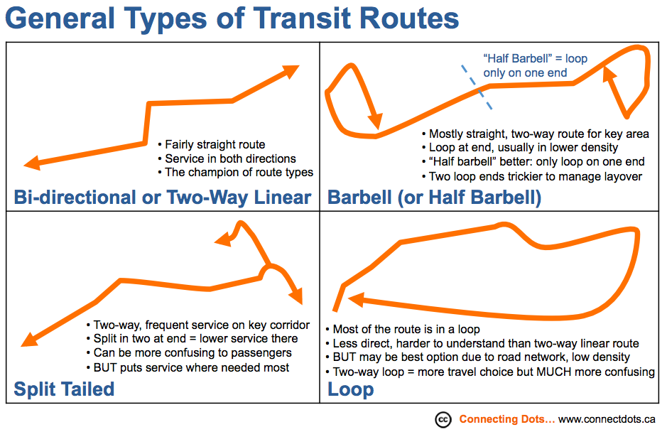
The more the route lines are straight, the more transit planners love ‘em and so do most passengers. Straighter lines are more likely to be the fastest point from A to B, meaning less time in transit for you and more frequent trips for the same cost.
Also, if the bus or train operates in both directions along the same relatively straight path (which we call a “two way” or “bi-directional” route), it will likely be easiest for people to understand.
When I’m traveling to downtown, I go to THIS side of the road or station platform and travel in THIS direction. When I’m coming home, I just need to go in the OPPOSITE direction on the same line. I’ll get off on the OTHER side from where I started.
Enter the Loop
Sometimes, however, curves and loops become necessary due to where key destinations have been placed in a community or because the road network has been designed in a way that makes straight-ish lines impossible.

A classic loop: Kitimat Transit’s 1A/1B Whitesail route is a structure begotten by its road network. (Source: BC Transit)
The thing about a loop, though, is that it becomes a bit harder for people to understand. When you look at a transit map to figure out where you need to go, you are essentially undertaking a mental miracle. You are translating the actual physical location of yourself on the planet into its spatial representation on a map and then back out again.
Picture yourself standing on a single straight line and trying to describe to someone else how to get to one end or the other. Now picture yourself standing on a circle and trying to do the same thing. A bit harder to do, yes? Which is “the end,” anyway?
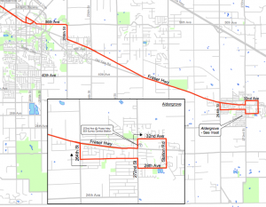
TransLink’s 503 Surrey Central/Aldergrove bus route is an example of how lines and loops can combine into what I call a “half barbell” route: mainly straight and two way along most of its path but with a loop at the outer end to provide circulation through a neighbourhood. (Source: TransLink; full route map here: http://infomaps.translink.ca/Route_Diagrams/125/r503.pdf)
Loops aren’t always bad. In fact, loops are often used to serve residential suburbs because they can be the most affordable way to provide service to areas of lower density that are spread out over a larger area.
While it may be less direct and convenient than two way service, that’s better than no service at all. And if the loop is relatively small and operates in one direction, it is normally fairly easy for people to understand.
However, operate that loop in both directions and you make it even harder for passengers to orient themselves to which way they need to go, particularly new users that you want to attract.
Think back to our “standing on a circle” example above. Now picture two large, amorphous blobby loops one inside the other and each rotating in a different direction. Now how would you describe which way to go to someone else? Clockwise and counterclockwise? Via a midway point?
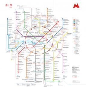
Spot the circles! Moscow Metropolitan.
You’re now also asking your test subject to think of clocks and random other places along the way. This is on top of the already laudable mental feat of linking physical place and its spatial representation. That doesn’t seem easy or convenient.
Sure, there are some pretty famous transit two-way loops, such as London’s Circle Line and key routes in Moscow and Beijing. But routes like that are relatively rare. (For more on the Circle Line and other related thoughts on loops, see also comments from Stephen Rees and Jarek at the bottom of this post). I try to avoid creating two-way loops myself wherever possible because I think they can act as a barrier to new customers using a transit system.
Taming the Two-Way Loop

A fellow who should be a patron saint of transit planners, magician Doug Henning would have known how to transform a route.
Much like we saw in my tirade on route lollipops, if you are stuck with a route structure you don’t like, there are a few ways you can make it better. In the case of two-way loops you can:
- Restructure your system to banish them – This is essentially what the TransLink change has done. While the new split tail on the end of the Expo Line adds a slightly tricky element, overall the new SkyTrain structure should provide much improved clarity once the dust settles. It also:
- Prepares the way for the upcoming Evergreen Extension and future extended transit along Broadway.
- Makes it more possible to match service to demand. (If one side of a loop has more ridership than the other, it’s harder to hone service to match those different needs; with separate lines you can do so much better).
- Reduces the appearance of duplication in the segment from Waterfront to Columbia Station, which again can make it easier for new customers to understand and take transit.
- Turn your two-way into one-way – Is that two-way loop really necessary? Unless there’s a really compelling string of destinations that people are going to need to access in both directions, in my opinion you’re better off just running a loop in one direction. Not only is it easier to understand, but it will appear to offer more frequency. For systems operated by buses, it also means you won’t get people feeling the need to breathlessly jackrabbit across the road when they see a bus coming in the opposite direction and they’re standing at the wrong stop.
- Marshall your inner Doug Henning and give the illusion of a couple linear routes – If you pick a strong destination point part-way through the loop (with a layover spot on a bus-based system) you can make it seem like the loop is actually two simple linear routes. Buses still operate the loop but drivers change the destination sign at the midway point. Savvy regulars are still able to take advantage of the loop structure but new users will be able to more clearly see their inbound and outbound trips.

The Victoria Regional Transit System‘s routes 56 and 57 used to be–and are still operated as–two halves of a pretty complex loop. However, to the public they are presented as two linear routes. (Still fairly confusing due to road network, yes, but waaaay better than it used to be, trust me….) Source: BC Transit
- Rename or renumber, if you must. As a last resort, you can always try to improve the clarity of your two-way loop by using different combinations of route numbering (like the Kitimat example, above) or direction names based on major destinations along the route (Via Extremely Mondo Mall, Via Hapless Industrial Enclave, etc.)
Be Patient, Think Big and Have Your Say in the Future
Extending higher quality transit services to new areas of the community is always something to be celebrated. AND, whether it be changing where a tiny 20 passenger bus goes in a rural community or shifting a light rail network serving millions, even the good changes are going to cause a period of upheaval.
While I certainly don’t envy the passengers and staff as they go through the process of shifting established travel patterns in Vancouver, I wish them well and hope this provides some further general context. You can also check out the very detailed explanation of the changes in the TransLink video at the bottom of this post with BC Rapid Transit Co.’s Manager of Operations Planning, Ian Fisher.
 In the meantime, right now until October 31, 2016 you can help shape the future of significant improvements planned for Metro Vancouver’s transportation network by taking the online Phase One 10-Year Vision survey. Read more about the project and its funding at the 10-Year Vision website or by checking out the Phase 1 Discussion Paper.
Good mobility stuff is coming, my Vancouver friends, and you can help make it happen. This is just the start and things are already looking less loopy.
The Circle Line in London no longer runs round in circles. The loop is broken at Edgware Road and the actual route looks like a number 9 – but in a mirror laid on its side. I hope that is a complex enough explanation. LUL did it, they said, to make it more reliable.
I think it worth adding that most of highest used bus routes in Vancouver run in very nearly straight lines. In many Old World cities this is not possible simply because building cities on a regular grid is a relatively recent phenomenon.
And the reason that so many low density suburban roads are laid out in loops – and banjos – is to deter through car traffic. It will take many years to break down these mazes, but forward looking places, which separate out bike, walk and transit from single occupant car and truck traffic are making a start by building short cuts for the more energy efficient modes. The only discipline which seems not to understand the human desire to walk in a straight line is landscape architecture.
Thanks very much for your thoughtful additions, Stephen. I’ve added a note into the text of the post so that readers check them out. Cheers!
Just to say that I lived in London for two years and would still struggle to explain how to find the right Circle line train – especially at Edgware Road! They seem to be using intermediate stations quite heavily in the train announcements, e.g. “via King’s Cross, Liverpool Street” vs “via High Street Kensington, Victoria” though it’s still problematic as you need two intermediate stations points and then think about the order they’re in.
Berlin S-Bahn took the out of naming the clockwise and counterclockwise lines as S41 and S42, which simplifies things a bit since trip planners can say “to get from station A to station B, take S41” and that’s unambiguous. OTOH, then the return trip is on a different line, which is a bit of a problem.
Thanks very much for your comments, Jarek. I think you describe the trade offs really well in terms of ways to try make two way loops more clear. I’ve included a note in the post so that readers check out your comments here as I think they totally contribute to the discussion. Thanks again, Tania
Pingback: Snapshots from Vancouver's CUTA transit conference: integrating mobility - Connecting Dots . . .